Ficheiro:American Three-toed Woodpecker Picoides dorsalis distribution map 2.png

Imagem numa resolução maior (756 × 800 píxeis, tamanho: 129 kB, tipo MIME: image/png)

Descrição do ficheiro

Descrição
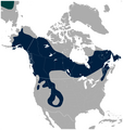
English: Geographical distribution of the American Three-toed Woodpecker Picoides dorsalis (navy). A small portion of the Eurasian Three-toed Woodpecker Picoides tridactylus range is visible in the upper left corner (deep cyan). Includes state and province borders.

Note: IUCN does not recognize Picoides dorsalis as separate species.

The map was created using the Generic Mapping Tools, GMT, version 5.1.2.
Data
Origem

Obra própria, usando: the IUCN Red List spatial data to draw the borders of the Picoides dorsalis and Picoides tridactylus range:
http://maps.iucnredlist.org/map.html?id=22727137
Credit for the spatial data:
BirdLife International and NatureServe (2014) Bird Species Distribution Maps of the World. 2014. Picoides tridactylus. In: IUCN 2014. The IUCN Red List of Threatened Species. Version 2014.3. http://www.iucnredlist.org. Downloaded on 26 May 2015.
Species account:
http://www.iucnredlist.org/details/22727137/0
BirdLife International 2014. Picoides tridactylus. The IUCN Red List of Threatened Species. Version 2014.3. <www.iucnredlist.org>. Downloaded on 26 May 2015.

 
Esta carta geográfica foi criada com o GMT.
Autor Darekk2 using the IUCN Red List spatial data
Outras versões Without Picoides tridactylus:
American Three-toed Woodpecker Picoides dorsalis distribution map.png

Licenciamento

Attribution: The author of the work and the IUCN Red List spatial data.
You must provide the appropriate credit for the IUCN Red List spatial data:
BirdLife International and NatureServe (2014) Bird Species Distribution Maps of the World. 2014. Picoides tridactylus. In: IUCN 2014. The IUCN Red List of Threatened Species. Version 2014.3. http://www.iucnredlist.org. Downloaded on 26 May 2015.

w:pt:Creative Commons
atribuição partilha nos termos da mesma licença
A utilização deste ficheiro é regulada nos termos da licença Creative Commons Atribuição-CompartilhaIgual 4.0 Internacional.
Atribuição: The author of the work
and the IUCN Red List spatial data
Pode:
  • partilhar – copiar, distribuir e transmitir a obra
  • recombinar – criar obras derivadas
De acordo com as seguintes condições:
  • atribuição – Tem de fazer a devida atribuição da autoria, fornecer uma hiperligação para a licença e indicar se foram feitas alterações. Pode fazê-lo de qualquer forma razoável, mas não de forma a sugerir que o licenciador o apoia ou subscreve o seu uso da obra.
  • partilha nos termos da mesma licença – Se remisturar, transformar ou ampliar o conteúdo, tem de distribuir as suas contribuições com a mesma licença ou uma licença compatível com a original.

Legendas

Adicione uma explicação de uma linha do que este ficheiro representa

Elementos retratados neste ficheiro

retrata

368cc7891e05ada5c94d07abb36f60eec1d9ed79

132 062 byte

800 pixel

756 pixel

Histórico do ficheiro

Clique uma data e hora para ver o ficheiro tal como ele se encontrava nessa altura.

Data e horaMiniaturaDimensõesUtilizadorComentário
atual02h29min de 27 de maio de 2015Miniatura da versão das 02h29min de 27 de maio de 2015756 × 800 (129 kB)Darekk2thinner borders of states
18h48min de 26 de maio de 2015Miniatura da versão das 18h48min de 26 de maio de 2015757 × 800 (133 kB)Darekk2thicker borders of states
18h21min de 26 de maio de 2015Miniatura da versão das 18h21min de 26 de maio de 2015756 × 800 (125 kB)Darekk2User created page with UploadWizard

A seguinte página usa este ficheiro:

Utilização global do ficheiro

As seguintes wikis usam este ficheiro: