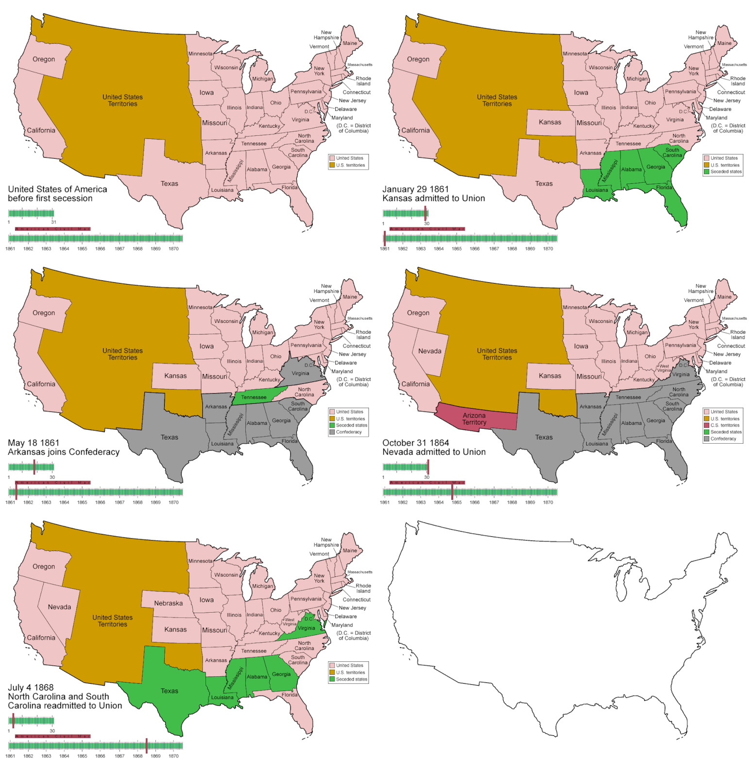
Ficheiro:CSA states evolution.gif

Dimensões desta antevisão: 800 × 542 píxeis. Outras resoluções: 320 × 217 píxeis | 640 × 433 píxeis | 1 000 × 677 píxeis.
Imagem numa resolução maior (1 000 × 677 píxeis, tamanho: 245 kB, tipo MIME: image/gif, cíclico, 38 quadros, 1 min 53 s)
Histórico do ficheiro
Clique uma data e hora para ver o ficheiro tal como ele se encontrava nessa altura.
| Data e hora | Miniatura | Dimensões | Utilizador | Comentário | |
|---|---|---|---|---|---|
| atual | 05h30min de 5 de junho de 2014 |  | 1 000 × 677 (245 kB) | RedXIV | Removed incorrect information. Kentucky and Missouri never seceded. The state governments of Kentucky and Missouri never voted to secede. Claiming that their secession actually happened gives an inaccurate impression of the actual sequence of events. |
| 10h56min de 21 de dezembro de 2013 |  | 1 000 × 677 (256 kB) | ChrisnHouston | I'm the one who broke the thumbnail. I'll try to fix it now... | |
| 13h38min de 20 de dezembro de 2013 |  | 1 000 × 677 (1,75 MB) | Afernand74 | No image displayed. Reupload to try to solve the problem | |
| 11h33min de 7 de novembro de 2013 |  | 1 000 × 677 (1,75 MB) | ChrisnHouston | Adding a bar to the timeline to indicate when the actual fighting of the Civil War happened, which is one of the most important aspects of this map. | |
| 15h18min de 11 de abril de 2012 |  | 1 000 × 677 (254 kB) | Golbez | rv - er, MO and KY were indeed admitted to the CSA, though it lacked any control over them. why not go to the talk page for the CSA on enwp and chat about my next version? | |
| 18h53min de 10 de abril de 2012 |  | 1 000 × 677 (225 kB) | Travürsa | Fixed errors. | |
| 01h57min de 18 de novembro de 2007 |  | 1 000 × 677 (254 kB) | Golbez | Removing frame of WV counties; that was incorrect, they were always part of WV | |
| 09h54min de 4 de março de 2007 |  | 1 000 × 677 (259 kB) | Golbez | == Summary == {{Information |Description=Animated map/timeline of the territorial evolution of the Confederate States of America, from first secession to end of Reconstruction. |Source=Self-made. |Date=March 2007 |Author=User:Golbez |Permission= see b |
Utilização local do ficheiro
As seguintes 2 páginas usam este ficheiro:
Utilização global do ficheiro
As seguintes wikis usam este ficheiro:
- af.wikipedia.org
- ar.wikipedia.org
- bcl.wikipedia.org
- cs.wikipedia.org
- da.wikipedia.org
- de.wikipedia.org
- en.wikipedia.org
- Confederate States of America
- Portal:United States/Selected picture
- User talk:-asx-
- User talk:Golbez/Archive 2
- Portal:Maps/Selected picture
- Wikipedia:Featured picture candidates/March-2007
- Wikipedia:Picture peer review/CSA evolution
- Wikipedia:Featured picture candidates/CSA states evolution.gif
- Wikipedia:Wikipedia Signpost/2007-03-20/Features and admins
- Wikipedia:Wikipedia Signpost/2007-03-20/SPV
- Portal:Maps/Selected picture/11
- Portal:United States/Selected picture/15
- Wikipedia:Featured picture candidates/November-2009
- Wikipedia:Featured picture candidates/Non-Native American Nations Control over N America 1750-2008.gif
- Wikipedia:Featured picture candidates/delist/2010
- Wikipedia:Featured picture candidates/delist/File:CSA states evolution.gif
- User:TheVirginiaHistorian/sandbox
- Wikipedia:Village pump (technical)/Archive 110
- User:Falcaorib/Canada, United States and Mexico
- eo.wikipedia.org
- eu.wikipedia.org
- fr.wikipedia.org
- fr.wiktionary.org
- fy.wikipedia.org
- hr.wikipedia.org
- hu.wikipedia.org
- id.wikipedia.org
- ja.wikipedia.org
- la.wikipedia.org
- ms.wikipedia.org
- ro.wikipedia.org
- sr.wikipedia.org
- th.wikipedia.org
- tr.wikipedia.org
- uk.wikipedia.org
