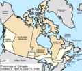
Ficheiro:Canada provinces 1895-1898.png

Dimensões desta antevisão: 694 × 600 píxeis. Outras resoluções: 278 × 240 píxeis | 556 × 480 píxeis | 1 000 × 864 píxeis.
Imagem numa resolução maior (1 000 × 864 píxeis, tamanho: 60 kB, tipo MIME: image/png)
Histórico do ficheiro
Clique uma data e hora para ver o ficheiro tal como ele se encontrava nessa altura.
| Data e hora | Miniatura | Dimensões | Utilizador | Comentário | |
|---|---|---|---|---|---|
| atual | 17h21min de 14 de julho de 2009 |  | 1 000 × 864 (60 kB) | Golbez | New color scheme, other borders |
| 09h59min de 7 de agosto de 2006 |  | 1 000 × 864 (46 kB) | Golbez | with legend | |
| 07h31min de 28 de março de 2006 |  | 1 000 × 864 (45 kB) | Golbez | fix wrong caption | |
| 02h24min de 18 de fevereiro de 2006 |  | 1 000 × 864 (44 kB) | Golbez | Better version | |
| 23h49min de 13 de fevereiro de 2006 |  | 1 000 × 864 (40 kB) | Golbez | better colors | |
| 09h28min de 13 de fevereiro de 2006 |  | 1 000 × 864 (40 kB) | Golbez | Map of the provinces and territories of Canada as they were from 1895 to 1898. In 1895, the District of Keewatin was enlarged. On June 13 1898, Yukon Territory is formed mostly from the District of Yukon in the North-West Territories, and Quebec is enlarg |
Utilização local do ficheiro
A seguinte página usa este ficheiro:
Utilização global do ficheiro
As seguintes wikis usam este ficheiro:
- de.wikipedia.org
- en.wikipedia.org
- es.wikipedia.org
- fr.wikipedia.org
- it.wikipedia.org
- ru.wikipedia.org
- uk.wikipedia.org
- vi.wikipedia.org
- zh.wikipedia.org
