Ficheiro:Decision Support System for John Day Reservoir.jpg

Decision_Support_System_for_John_Day_Reservoir.jpg (477 × 364 píxeis, tamanho: 178 kB, tipo MIME: image/jpeg)

Descrição do ficheiro

Descrição
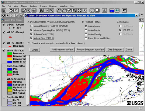
English: This set of tools, in conjunction with 2-dimensional hydraulic modeling, is being used to estimate the effects of reservoir level and water discharge fluctuations on aquatic and terrestrial habitats in John Day Reservoir. Different scenarios being studied now range from typical reservoir levels at high and low discharges to a simulation of what things might be like if the river were to return to natural conditions
Data Retrieved June 17 2009.
Origem http://wfrc.usgs.gov/research/geospatial%20studies/STGeospat4.htm ...returns HTTP status 404. The most recent non-404 snapshot of this page from archive.org is: https://web.archive.org/web/20100527105316/http://wfrc.usgs.gov/research/geospatial%20studies/STGeospat4.htm
Autor USGS: Project contact Michael J. Parsley, U.S. Geological Survey

Licenciamento

Public domain
Esta imagem está no domínio público porque ela contém materiais originalmente provenientes do Serviço Geológico dos Estados Unidos, uma agência do Departamento do Interior dos Estados Unidos. Para mais informações, veja a política oficial da USGS em relação a direitos autorais

Bahasa Indonesia  català  čeština  Deutsch  eesti  English  español  français  galego  italiano  Nederlands  português  polski  sicilianu  suomi  Tiếng Việt  Türkçe  български  македонски  русский  മലയാളം  한국어  日本語  中文  中文(简体)  中文(繁體)  العربية  فارسی  +/−

Legendas

Adicione uma explicação de uma linha do que este ficheiro representa

Elementos retratados neste ficheiro

retrata

182 212 byte

364 pixel

477 pixel

image/jpeg

4a73bf3fdc55a87744768b3e7e4b2a0f198588f0

Histórico do ficheiro

Clique uma data e hora para ver o ficheiro tal como ele se encontrava nessa altura.

Data e horaMiniaturaDimensõesUtilizadorComentário
atual11h40min de 17 de junho de 2009Miniatura da versão das 11h40min de 17 de junho de 2009477 × 364 (178 kB)Mdd{{Information |Description={{en|1=This set of tools, in conjunction with 2-dimensional hydraulic modeling, is being used to estimate the effects of reservoir level and water discharge fluctuations on aquatic and terrestrial habitats in John Day Reservoir.

A seguinte página usa este ficheiro:

Utilização global do ficheiro

Metadados