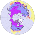
Ficheiro:Frozenground.gif
Frozenground.gif (352 × 350 píxeis, tamanho: 34 kB, tipo MIME: image/gif)
Histórico do ficheiro
Clique uma data e hora para ver o ficheiro tal como ele se encontrava nessa altura.
| Data e hora | Miniatura | Dimensões | Utilizador | Comentário | |
|---|---|---|---|---|---|
| atual | 12h02min de 19 de junho de 2016 |  | 352 × 350 (34 kB) | SteinsplitterBot | Bot: Image rotated by 270° |
| 18h10min de 3 de julho de 2005 |  | 350 × 352 (33 kB) | Adam~commonswiki | Distributions of permafrost in the Northern Hemispher. *purple region : permafrost *blue regions : seasonally frozen ground (the soil is frozen for 15 days or more per year ) *pink regions : intermittently frozen ground ( the soil is frozen for fewer t | |
| 01h00min de 18 de abril de 2005 |  | 350 × 372 (33 kB) | Ktz~commonswiki | Distributions of permafrost in the Nortern Hemispher. {{PD-USGov-NASA}} http://earthobservatory.nasa.gov/Study/FrozenSoils/ |
Utilização local do ficheiro
A seguinte página usa este ficheiro:
Utilização global do ficheiro
As seguintes wikis usam este ficheiro:
- ar.wikipedia.org
- arz.wikipedia.org
- ast.wikipedia.org
- az.wikipedia.org
- be-tarask.wikipedia.org
- be.wikipedia.org
- bg.wikipedia.org
- bn.wikipedia.org
- cdo.wikipedia.org
- cv.wikipedia.org
- da.wikipedia.org
- en.wikipedia.org
- eo.wikipedia.org
- es.wikipedia.org
- es.wikibooks.org
- et.wikipedia.org
- fi.wikipedia.org
- fr.wikipedia.org
- fy.wikipedia.org
- hu.wikipedia.org
- hy.wikipedia.org
- ilo.wikipedia.org
- ja.wikipedia.org
- jv.wikipedia.org
- kn.wikipedia.org
- la.wikipedia.org
- li.wikipedia.org
- lv.wikipedia.org
- ms.wikipedia.org
- nl.wikipedia.org
- nn.wikipedia.org
- no.wikipedia.org
- pa.wikipedia.org
- pl.wikipedia.org
- ru.wikipedia.org
- sah.wikipedia.org
- sk.wikipedia.org
- sq.wikipedia.org
- sr.wikipedia.org
- ta.wikipedia.org
- te.wikipedia.org
- tr.wikipedia.org
- uk.wikipedia.org
- vi.wikipedia.org
- wuu.wikipedia.org
- zh.wikipedia.org


