Ficheiro:Highland UK relief location map.jpg

Dimensões desta antevisão: 555 × 599 píxeis. Outras resoluções: 222 × 240 píxeis | 445 × 480 píxeis | 711 × 768 píxeis | 949 × 1 024 píxeis | 2 000 × 2 159 píxeis.
Imagem numa resolução maior (2 000 × 2 159 píxeis, tamanho: 967 kB, tipo MIME: image/jpeg)
|
|
Esta imagem provém do Wikimedia Commons, um acervo de conteúdo livre da Wikimedia Foundation que pode ser utilizado por outros projetos.
|
| Descrição |
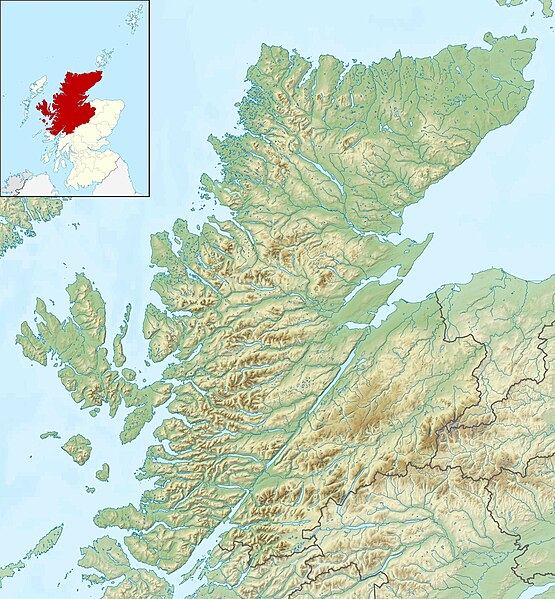
Relief map of Highland, UK. Equirectangular map projection on WGS 84 datum, with N/S stretched 180% Geographic limits:
|
| Data | |
| Origem |
|
| Autor | Nilfanion, created using Ordnance Survey data |
| Permissão (Reutilizar este ficheiro) |
A utilização deste ficheiro é regulada nos termos da licença Creative Commons - Atribuição-CompartilhaIgual 3.0 Não Adaptada. Atribuição: Contains Ordnance Survey data © Crown copyright and database right
|
| Outras versões | File:Highland UK blank map.svg - Blank map |
Histórico do ficheiro
Clique uma data e hora para ver o ficheiro tal como ele se encontrava nessa altura.
| Data e hora | Miniatura | Dimensões | Utilizador | Comentário | |
|---|---|---|---|---|---|
| atual | 12h22min de 30 de novembro de 2011 | | 2 000 × 2 159 (967 kB) | Nilfanion | {{Information |Description=Relief map of Highland, UK. Equirectangular map projection on WGS 84 datum, with N/S stretched 180% Geographic limits: *West: 6.9W *East: 2.9W *North: 58.8N *South: 56.4N |Source=[[w:Ordnance Surv |
Utilização local do ficheiro
A seguinte página usa este ficheiro:
Utilização global do ficheiro
As seguintes wikis usam este ficheiro:
- ar.wikipedia.org
- arz.wikipedia.org
- ba.wikipedia.org
- bg.wikipedia.org
- ceb.wikipedia.org
- de.wikipedia.org
- Innere Hebriden
- Loch Ness
- Ben Nevis
- Eilean Donan Castle
- Urquhart Castle
- Canna
- Loch Morar
- Loch Linnhe
- Ardnamurchan
- Loch Oich
- Loch Shin
- Girnigoe and Sinclair Castle
- Dunvegan Castle
- Eilean Horrisdale
- Camus nan Geall
- Glen Coe
- Loch Lochy
- Loch Arkaig
- Loch Maree
- Ballone Castle
- Soay (Innere Hebriden)
- Ascrib Islands
- Eilean Trodday
- Wiay
- Loch Shiel
- Bealach na Bà
- Loch Assynt
- Loch Affric
- Loch Beinn a’ Mheadhoin
- Loch Cluanie
- Loch Coruisk
- Loch Dochfour
- Loch Dùghaill
- Loch an Eilean
- Loch Einich
- Loch Ericht
- Loch Loyal
- Càrn Eighe
- Cairn Gorm
- Glen Affric
- Brochel Castle
Ver mais utilizações globais deste ficheiro.