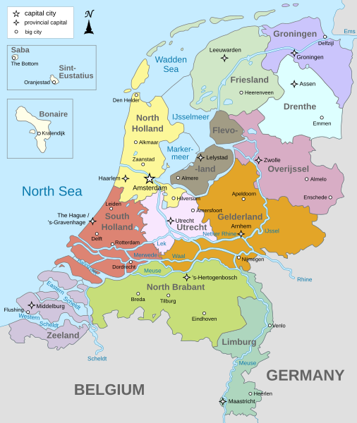
Ficheiro:Map provinces Netherlands-en.svg

Dimensões desta antevisão em PNG do ficheiro SVG: 506 × 600 píxeis Outras resoluções: 202 × 240 píxeis | 405 × 480 píxeis | 648 × 768 píxeis | 864 × 1 024 píxeis | 1 727 × 2 048 píxeis | 743 × 881 píxeis.
Imagem numa resolução maior (ficheiro SVG, de 743 × 881 píxeis, tamanho: 1 003 kB)
Histórico do ficheiro
Clique uma data e hora para ver o ficheiro tal como ele se encontrava nessa altura.
| Data e hora | Miniatura | Dimensões | Utilizador | Comentário | |
|---|---|---|---|---|---|
| atual | 19h28min de 19 de janeiro de 2024 |  | 743 × 881 (1 003 kB) | Illchy | File uploaded using svgtranslate tool (https://svgtranslate.toolforge.org/). Added translation for id. |
| 17h43min de 29 de abril de 2023 |  | 743 × 881 (987 kB) | Dymitr | File uploaded using svgtranslate tool (https://svgtranslate.toolforge.org/). Added translation for be-tarask. | |
| 09h27min de 25 de novembro de 2021 |  | 743 × 881 (909 kB) | Andrei Stroe | File uploaded using svgtranslate tool (https://svgtranslate.toolforge.org/). Added translation for ro. | |
| 08h39min de 12 de abril de 2019 |  | 743 × 881 (811 kB) | Thayts | Tweaked text position | |
| 11h32min de 17 de fevereiro de 2019 |  | 743 × 881 (811 kB) | Thayts | Fixed svg | |
| 11h18min de 17 de fevereiro de 2019 |  | 743 × 881 (811 kB) | Thayts | Added a bit more spacing between Eastern/Western and Scheldt | |
| 11h06min de 17 de fevereiro de 2019 |  | 743 × 881 (811 kB) | Thayts | Fixed Eastern Scheldt which wasn't rendered by the MediaWiki engine; removed Belgian city of Antwerp | |
| 05h21min de 14 de fevereiro de 2019 |  | 743 × 881 (809 kB) | Alphathon | Updated borders | |
| 20h34min de 23 de agosto de 2015 |  | 743 × 881 (847 kB) | Alphathon | Fixed stroke weight on a Friesland lake | |
| 20h27min de 23 de agosto de 2015 |  | 743 × 881 (847 kB) | Alphathon | Covered over the strokes at the mouths of rivers |
Utilização local do ficheiro
As seguintes 2 páginas usam este ficheiro:
Utilização global do ficheiro
As seguintes wikis usam este ficheiro:
- ace.wikipedia.org
- af.wikipedia.org
- ang.wikipedia.org
- an.wikipedia.org
- ar.wikipedia.org
- ay.wikipedia.org
- azb.wikipedia.org
- be-tarask.wikipedia.org
- bg.wikipedia.org
- blk.wikipedia.org
- bn.wikipedia.org
- ceb.wikipedia.org
- diq.wikipedia.org
- en.wikipedia.org
- Netherlands
- Provinces of the Netherlands
- List of islands of the Netherlands
- King's commissioner
- Geology of the Netherlands
- File talk:Netherlands map large.png
- French war planning 1920–1940
- User talk:Gidonb/Archive 2008
- Template:Provinces of the Netherlands imagemap
- List of windmills in the Netherlands
- Provincial politics in the Netherlands
- 2008–09 KNVB Cup
- User:Alphathon/Gallery
- File talk:Netherlands Map.svg
- Portal:Islands
- Wikipedia:Reference desk/Archives/Humanities/2014 September 25
- en.wikiversity.org
- eu.wikipedia.org
- fa.wikipedia.org
- ff.wikipedia.org
- fi.wikipedia.org
- fr.wikipedia.org
- gl.wikipedia.org
- haw.wikipedia.org
- he.wikipedia.org
- ia.wikipedia.org
- id.wikipedia.org
Ver mais utilizações globais deste ficheiro.


