Ficheiro:Military districts of Russia 2016.svg

Dimensões desta antevisão em PNG do ficheiro SVG: 800 × 455 píxeis Outras resoluções: 320 × 182 píxeis | 640 × 364 píxeis | 1 024 × 583 píxeis | 1 280 × 728 píxeis | 2 560 × 1 457 píxeis | 1 107 × 630 píxeis.
Imagem numa resolução maior (ficheiro SVG, de 1 107 × 630 píxeis, tamanho: 263 kB)
|
|
Esta imagem provém do Wikimedia Commons, um acervo de conteúdo livre da Wikimedia Foundation que pode ser utilizado por outros projetos.
|

|
As fronteiras deste mapa refletem a situação de facto e não implicam a sua aprovação ou aceitação. |
Descrição do ficheiro
| Descrição |
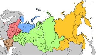
Русский: Военно-административное деление территории Российской Федерации с 15 декабря 2014 года
Западный военный округ
Северный флот
Южный военный округ
Центральный военный округ
Восточный военный округ English: Areas of responsibility of the 5 Operational Strategic Commands of the Russian Armed Forces since Dec 15th, 2014
Western Operational Strategic Command
Northern Fleet
Southern Operational Strategic Command
Central Operational Strategic Command
Eastern Operational Strategic Command |
| Data | |
| Origem | |
| Autor | AlexWelens |

Licenciamento
Eu, titular dos direitos de autor desta obra, publico-a com a seguinte licença:
A utilização deste ficheiro é regulada nos termos da licença Creative Commons Atribuição-CompartilhaIgual 4.0 Internacional.
- Pode:
- partilhar – copiar, distribuir e transmitir a obra
- recombinar – criar obras derivadas
- De acordo com as seguintes condições:
- atribuição – Tem de fazer a devida atribuição da autoria, fornecer uma hiperligação para a licença e indicar se foram feitas alterações. Pode fazê-lo de qualquer forma razoável, mas não de forma a sugerir que o licenciador o apoia ou subscreve o seu uso da obra.
- partilha nos termos da mesma licença – Se remisturar, transformar ou ampliar o conteúdo, tem de distribuir as suas contribuições com a mesma licença ou uma licença compatível com a original.
Histórico do ficheiro
Clique uma data e hora para ver o ficheiro tal como ele se encontrava nessa altura.
| Data e hora | Miniatura | Dimensões | Utilizador | Comentário | |
|---|---|---|---|---|---|
| atual | 16h20min de 18 de novembro de 2024 | | 1 107 × 630 (263 kB) | Ecrusized | Crimea is internationally recognized as Ukrainian territory |
| 22h56min de 23 de dezembro de 2020 |  | 1 107 × 630 (263 kB) | AlexWelens | fixed islands according map at mil.ru | |
| 15h06min de 17 de fevereiro de 2017 |  | 1 107 × 630 (263 kB) | AlexWelens | Reverted to version as of 16:50, 15 July 2016 (UTC) | |
| 01h38min de 9 de fevereiro de 2017 |  | 1 107 × 630 (489 kB) | Metrancya | The Northern Fleet area of responsibility is only a part of the area of the new "Unified Strategic Command »North«. All territories north of the Arctic Circle will in the future be governed by the "Unified Strategic Command »North«, which then will... | |
| 16h50min de 15 de julho de 2016 |  | 1 107 × 630 (263 kB) | AlexWelens | User created page with UploadWizard |
Utilização local do ficheiro
A seguinte página usa este ficheiro:
Utilização global do ficheiro
As seguintes wikis usam este ficheiro:
- ar.wikipedia.org
- ast.wikipedia.org
- be-tarask.wikipedia.org
- bg.wikipedia.org
- cs.wikipedia.org
- da.wikipedia.org
- de.wikipedia.org
- en.wikipedia.org
- es.wikipedia.org
- et.wikipedia.org
- fi.wikipedia.org
- fr.wikipedia.org
- he.wikipedia.org
- hu.wikipedia.org
- it.wikipedia.org
- ja.wikipedia.org
- lv.wikipedia.org
- mn.wikipedia.org
- my.wikipedia.org
Ver mais utilizações globais deste ficheiro.