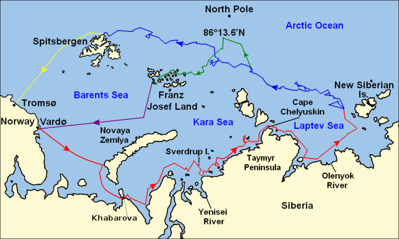
Ficheiro:Nansen Fram Map.png
Nansen_Fram_Map.png (800 × 479 píxeis, tamanho: 195 kB, tipo MIME: image/png)
Histórico do ficheiro
Clique uma data e hora para ver o ficheiro tal como ele se encontrava nessa altura.
| Data e hora | Miniatura | Dimensões | Utilizador | Comentário | |
|---|---|---|---|---|---|
| atual | 12h16min de 8 de maio de 2011 |  | 800 × 479 (195 kB) | Chris55 | Added [http://website.lineone.net/~polar.publishing/khabarova.htm Khabarova] where they picked up the dogs. |
| 15h50min de 21 de outubro de 2009 |  | 1 003 × 601 (78 kB) | Ruhrfisch | Make arrowheads less triangular (indentations at rear) | |
| 15h23min de 21 de outubro de 2009 |  | 1 003 × 601 (78 kB) | Ruhrfisch | Add arrowheads per FAC | |
| 18h50min de 20 de outubro de 2009 |  | 1 003 × 601 (78 kB) | Ruhrfisch | Make magenta line purple | |
| 13h36min de 11 de outubro de 2009 |  | 1 003 × 601 (78 kB) | Ruhrfisch | Yellow line for orange, some labels smaller, Farthest North replaced with actual figure, all other info the same | |
| 03h08min de 11 de outubro de 2009 |  | 1 003 × 601 (80 kB) | Ruhrfisch | Darker green for that line, all other information is the same | |
| 02h46min de 11 de outubro de 2009 |  | 1 003 × 601 (80 kB) | Ruhrfisch | Added last two lines for ice voyages, added last labels, all other information the same. | |
| 19h30min de 9 de outubro de 2009 |  | 1 003 × 601 (73 kB) | Ruhrfisch | Add labels, two more voyage lines, all other information is the same | |
| 16h12min de 9 de outubro de 2009 |  | 1 003 × 601 (57 kB) | Ruhrfisch | == Summary == {{Information |Description = Map of the Arctic Ocean showing the path of Nansen's Fram expedition 1893 to 1896 |Source = Base map of European mainland is from [[:File:Map of Russian Subjects old.png] |
Utilização local do ficheiro
As seguintes 3 páginas usam este ficheiro:
Utilização global do ficheiro
As seguintes wikis usam este ficheiro:
- bg.wikipedia.org
- en.wikipedia.org
- es.wikipedia.org
- fr.wikipedia.org
- hr.wikipedia.org
- id.wikipedia.org
- ja.wikipedia.org
- sl.wikipedia.org


