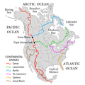
Ficheiro:NorthAmerica-WaterDivides.png

Dimensões desta antevisão: 600 × 600 píxeis. Outras resoluções: 240 × 240 píxeis | 480 × 480 píxeis | 900 × 900 píxeis.
Imagem numa resolução maior (900 × 900 píxeis, tamanho: 370 kB, tipo MIME: image/png)
Histórico do ficheiro
Clique uma data e hora para ver o ficheiro tal como ele se encontrava nessa altura.
| Data e hora | Miniatura | Dimensões | Utilizador | Comentário | |
|---|---|---|---|---|---|
| atual | 02h47min de 1 de outubro de 2019 |  | 900 × 900 (370 kB) | Palaeozoic99 | Correct St. Lawrence |
| 07h12min de 22 de novembro de 2018 |  | 900 × 900 (440 kB) | Pfly | Try to remove transparency one more time, sigh | |
| 06h51min de 22 de novembro de 2018 |  | 900 × 900 (290 kB) | Pfly | Reverting to original with non-transparent background, as the transparency was displaying very badly, even unreadably, on mobile devices | |
| 06h49min de 22 de novembro de 2018 |  | 900 × 900 (256 kB) | Pfly | revert my own reversion--made mistake | |
| 06h44min de 22 de novembro de 2018 |  | 900 × 900 (290 kB) | Pfly | Reverted to version as of 21:09, 23 November 2010 (UTC): Transparent background looks very bad, even unreadable on mobile. | |
| 02h46min de 15 de julho de 2012 |  | 900 × 900 (256 kB) | Ubiquinoid | mildly updated: including names of oceans/seas in vicinity of North America (as displayed), per IHO | |
| 02h43min de 15 de julho de 2012 |  | 900 × 900 (256 kB) | Ubiquinoid | mildly updated: including names of oceans/seas in vicinity of North America (as displayed), per IHO | |
| 21h09min de 23 de novembro de 2010 |  | 900 × 900 (290 kB) | Pfly | {{Information |Description={{en|1=Map showing the major Continental divides of North America, following the style of File:NorthAmericaDivides.gif and intended as a replacement. Made using [[:File:BlankMap-North America-Subd |
Utilização local do ficheiro
As seguintes 5 páginas usam este ficheiro:
Utilização global do ficheiro
As seguintes wikis usam este ficheiro:
- ar.wikipedia.org
- bs.wikipedia.org
- cs.wikipedia.org
- de.wikipedia.org
- en.wikipedia.org
- North America
- List of rivers of the Americas
- Royal Proclamation of 1763
- Continental Divide of the Americas
- Rupert's Land
- Pigeon River (Minnesota–Ontario)
- Atlantic seaboard watershed
- Eastern Continental Divide
- Talk:Kensington Runestone
- Talk:List of lighthouses in the United States
- Great Divide Basin
- Central United States
- Triple Divide Peak (Montana)
- Chicago Portage
- Snow Dome (Canada)
- Hudson Bay drainage basin
- Geography of North America
- Laurentian Divide
- Continental divide
- River
- Talk:River
- Great Basin Divide
- Watersheds of North America
- Canadian canoe routes
- Voyageurs
- Pacific Slope
- Centennial Voyageur Canoe Pageant
- Triple divide
- St. Lawrence River Divide
- Timeline of Alberta history
- en.wiktionary.org
- eo.wikipedia.org
- es.wikipedia.org
- fr.wikipedia.org
- hr.wikipedia.org
- hy.wikipedia.org
Ver mais utilizações globais deste ficheiro.
