Ficheiro:Scandinavia1219.png
Dimensões desta antevisão: 513 × 600 píxeis. Outras resoluções: 205 × 240 píxeis | 410 × 480 píxeis | 657 × 768 píxeis | 876 × 1 024 píxeis | 1 500 × 1 754 píxeis.
Imagem numa resolução maior (1 500 × 1 754 píxeis, tamanho: 41 kB, tipo MIME: image/png)
|
|
Esta imagem provém do Wikimedia Commons, um acervo de conteúdo livre da Wikimedia Foundation que pode ser utilizado por outros projetos.
|
| Descrição |
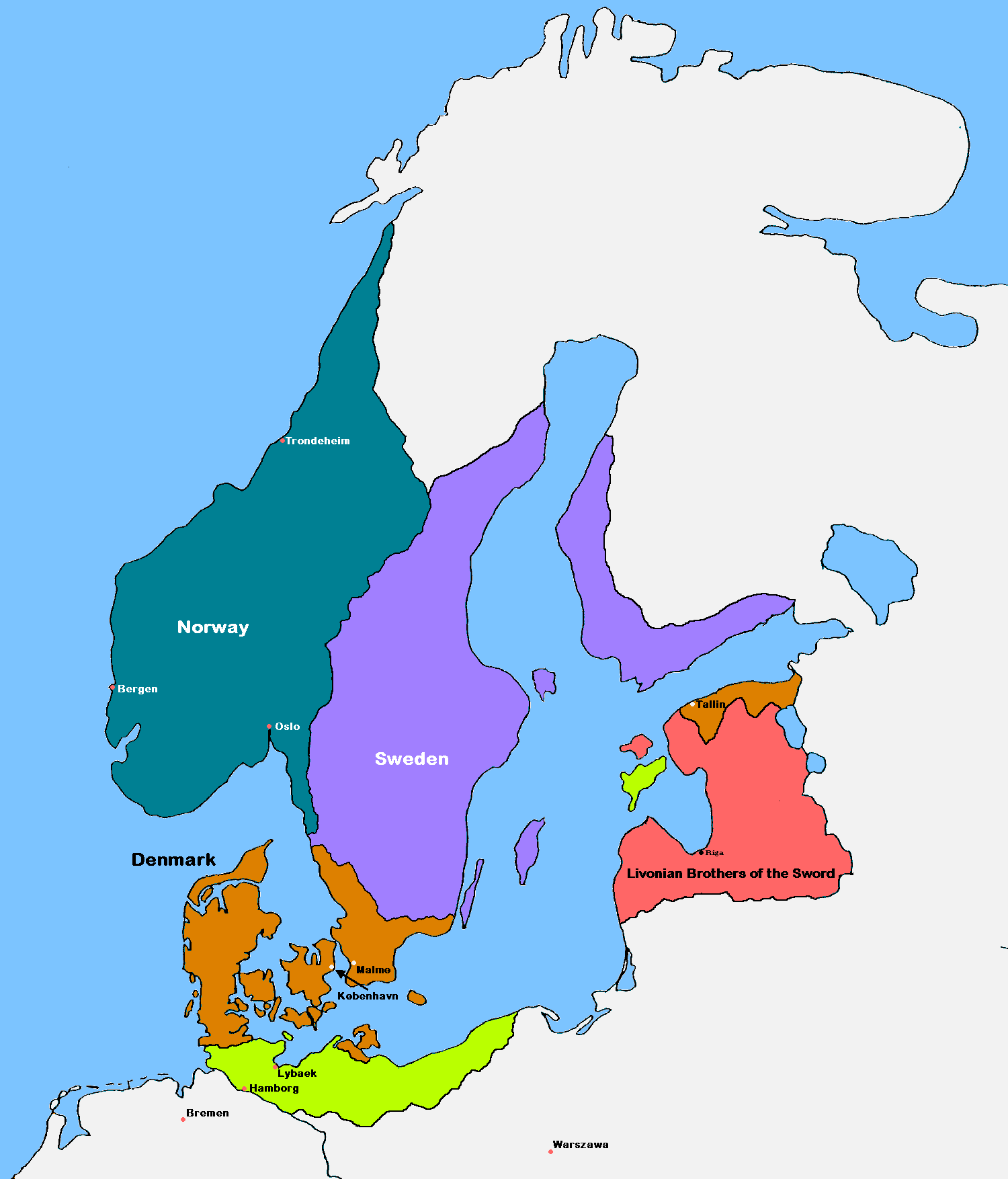
English: Update of the historical and political map, created in 2005 by Kasper Holl. It is a compressed format, has an easier colour scheme and has greater sized labels. NB on accuracy: Sweden did not reach this size until after the 1330s, when colonialization of Västerbotten started. Swedish colonialization of Finnish coast started before 1250. Sweden lost Gotland to Denmark in 1361. Trondheim has a wrong placement on map.
Denmark
Norway
Sweden
The Sword Brethren
Territories conquered by Denmark in 1219 |
| Data | (UTC) |
| Origem |
|
| Autor | MasterOfHisOwnDomain |
| Outras versões |
|

Eu, titular dos direitos de autor desta obra, publico-a com as seguintes licenças:

|
É concedida permissão para copiar, distribuir e/ou modificar este documento nos termos da Licença de Documentação Livre GNU, versão 1.2 ou qualquer versão posterior publicada pela Free Software Foundation; sem Secções Invariantes, sem textos de Capa e sem textos de Contra-Capa. É incluída uma cópia da licença na secção intitulada GNU Free Documentation License. |
| A utilização deste ficheiro é regulada nos termos da licença Creative Commons - Atribuição-CompartilhaIgual 3.0 Não Adaptada. | ||
| ||
| Esta marca de licenciamento foi adicionada a este ficheiro durante a atualização da licença GFDL. |
Pode escolher a licença que quiser.
Histórico do ficheiro
Clique uma data e hora para ver o ficheiro tal como ele se encontrava nessa altura.
| Data e hora | Miniatura | Dimensões | Utilizador | Comentário | |
|---|---|---|---|---|---|
| atual | 17h18min de 16 de setembro de 2016 | | 1 500 × 1 754 (41 kB) | VulpesVulpes42 | According to the description, the cities of Stockholm and Göteborg did not exist in 1219, so I removed them from the map. |
| 14h37min de 12 de agosto de 2009 |  | 1 500 × 1 754 (68 kB) | MasterOfHisOwnDomain | Update of the historical and political map, created in 2005 by Kasper Holl. It is a compressed format, has an easier colour scheme and has greater sized labels. {{Self|GFDL|Cc-by-sa-3.0-migrated}} Category:Maps of the history of Denmark [[Category: |
Utilização local do ficheiro
A seguinte página usa este ficheiro:
Utilização global do ficheiro
As seguintes wikis usam este ficheiro:
- ast.wikipedia.org
- be.wikipedia.org
- ca.wikipedia.org
- cs.wikipedia.org
- da.wikipedia.org
- de.wikipedia.org
- dsb.wikipedia.org
- el.wikipedia.org
- en.wikipedia.org
- Northern Crusades
- History of Denmark
- Valdemar II of Denmark
- Duchy of Pomerania
- Otto I, Duke of Brunswick-Lüneburg
- Battle of Bornhöved (1227)
- Christianization of Pomerania
- Dominium maris baltici
- Template:Scandinavia map, 1219
- Denmark–Sweden border
- Borders of Denmark
- User:Falcaorib/Baltic States
- User:Falcaorib/Sweden and Finland
- eo.wikipedia.org
- es.wikipedia.org
- et.wikipedia.org
- fr.wikipedia.org
Ver mais utilizações globais deste ficheiro.