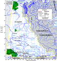
Ficheiro:Yukonwikimap.PNG

Dimensões desta antevisão: 559 × 600 píxeis. Outras resoluções: 224 × 240 píxeis | 447 × 480 píxeis | 863 × 926 píxeis.
Imagem numa resolução maior (863 × 926 píxeis, tamanho: 96 kB, tipo MIME: image/png)
Histórico do ficheiro
Clique uma data e hora para ver o ficheiro tal como ele se encontrava nessa altura.
| Data e hora | Miniatura | Dimensões | Utilizador | Comentário | |
|---|---|---|---|---|---|
| atual | 12h29min de 13 de junho de 2010 |  | 863 × 926 (96 kB) | Jahoe | For some reason this map exists both on commons and English wikipedia, using the same file name. It turned out that the one here on commons was an old version (with the longitudes reversed). This upload synchronizes both versions. |
| 00h38min de 21 de setembro de 2006 |  | 863 × 926 (169 kB) | Góngora | Map of the Yukon created by Earl Andrew, a wikipedian belonging to English Wikipedia. {{PD|Earl Andrew}} |
Utilização local do ficheiro
A seguinte página usa este ficheiro:
Utilização global do ficheiro
As seguintes wikis usam este ficheiro:
- af.wikipedia.org
- be-tarask.wikipedia.org
- ca.wikipedia.org
- de.wikipedia.org
- en.wikipedia.org
- es.wikipedia.org
- fr.wikipedia.org
- fy.wikipedia.org
- gl.wikipedia.org
- hi.wikipedia.org
- hy.wikipedia.org
- id.wikipedia.org
- ilo.wikipedia.org
- it.wikipedia.org
- Liard
- Geografia dello Yukon
- Fiumi dello Yukon
- Peel (fiume Canada)
- Wind (fiume)
- Teslin (fiume)
- Snake (fiume Yukon)
- Donjek
- Firth (fiume)
- Aishihik (fiume)
- Dezadeash
- Bonnet Plume
- Blackstone (fiume Yukon)
- Hart (fiume)
- Big Salmon
- Frances (fiume)
- Hyland (fiume)
- La Biche (affluente Liard)
- Babbage (fiume)
- Smith (fiume)
- Indian (fiume Yukon)
- Kaskawulsh
- ja.wikipedia.org
- mn.wikipedia.org
- nl.wikipedia.org
Ver mais utilizações globais deste ficheiro.
