Ficheiro:Hindu Kush satellite image.jpg
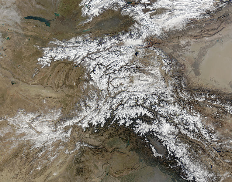
Imagem numa resolução maior (5 600 × 4 400 píxeis, tamanho: 5,01 MB, tipo MIME: image/jpeg)

Descrição do ficheiro

Descrição The Hindu Kush occupies the lower-left-center of this true-color MODIS satellite image, acquired 28 November 2003.
Data
Origem NASA's Earth Observatory
Autor Jeff Schmaltz, MODIS Land Rapid Response Team at NASA GSFC
Permissão
(Reutilizar este ficheiro)
Public domain - original work of NASA
Outras versões

Obras derivadas deste ficheiro:  High Asia Mountain Ranges.jpg

Earth Observatory text: [1]

Once used by Alexander the Great in his effort to conquer the known world, the high-altitude passes of the Hindu Kush remain important trade and travel routes. Glaciers and heavy snowfall are ever-present features of these mountains, which rise to 7,692 meters (26,236 feet) in height.

Straddling the borders between Pakistan, Afghanistan, and India, the Hindu Kush is heavily populated. Though the valleys are heavily irrigated, growing crops at such high altitudes and low temperatures is difficult. The residents also have to worry about earthquakes, which are common as the Eurasian and Indo-Australian tectonic plates continue to push against one-another. This constant pressure and grinding create an average of four major (measuring at least 5 on the Richter scale) earthquakes a year.

In this true-color Terra Moderate Resolution Imaging Spectroradiometer (MODIS) image, the Hindu Kush occupies the lower-left-center of the image. To the left are the relatively lower altitude plains of southern Kazakhstan, Uzbekistan, Turkmenistan, Afghanistan, and Pakistan. The fertile plains surrounding the northern strands of the Indus River are a deep green at the bottom center of the image (a translucent veil of smog adds a gray tinge to the region). Straddling the mountains north of the Kush are Kyrgyzstan and Tajikistan, which butt up against the arid Tarim basin of northwestern China. The Silk Road, the all-important trade route between China and Europe, runs through the Hindu Kush and this basin. This true-color Terra MODIS image was acquired on November 28, 2003.

Image courtesy Jeff Schmaltz, MODIS Land Rapid Response Team at NASA GSFC

Licenciamento

Public domain Este ficheiro está no domínio público nos Estados Unidos porque foi criado exclusivamente pela NASA. As orientações sobre o direito de autor da NASA são que «as obras da NASA não têm os direitos de autor protegidos salvo indicação em contrário». Veja Template:PD-USGov, as orientações sobre o direito de autor da NASA ou as normas de uso de imagens do Laboratório de Propulsão a Jato (Jet Propulsion Lab, JPL).
Avisos:

Legendas

Adicione uma explicação de uma linha do que este ficheiro representa

Elementos retratados neste ficheiro

retrata

Histórico do ficheiro

Clique uma data e hora para ver o ficheiro tal como ele se encontrava nessa altura.

Data e horaMiniaturaDimensõesUtilizadorComentário
atual04h39min de 6 de junho de 2006Miniatura da versão das 04h39min de 6 de junho de 20065 600 × 4 400 (5,01 MB)Avenue{{Information |Description=The Hindu Kush occupies the lower-left-center of this true-color MODIS satellite image, acquired 28 November 2003. |Source=[NASA's Earth Observatory http://earthobservatory.nasa.gov/Newsroom/NewImages/images.php3?img_id=16411] |

As seguintes 2 páginas usam este ficheiro:

Utilização global do ficheiro

As seguintes wikis usam este ficheiro:

Metadados